6 BILLION CELL PHONES: A UNIVERSAL ACCESS POINT FOR NEW SERVICES
October 4, 2013
More and more people in the world use cell phones or smartphones: 6 billion mobile phones are used on a regular basis on earth, and this number is increasing. Of those six billion phones, five billions are in developing countries. We could say that nearly everybody has a cell phone and uses it. Today, most of them are cheap phones that can do little besides making calls and sending text messages, but in the near future, smart phones will become the standard for communication.
Using phone infrastructure (from basic or smartphone one), which is widely spread in all the countries (even in developing countries), to gather data in order to provide services to the population is a promising way, especially in those poor countries generally lacking data-gathering infrastructure.
Here are two examples:
The first one creates disease-fighting tools leveraging cell-phone mobility data.
Caroline Buckee and al. from Harvard University is using mobility data from cell-phone (geo localization and timestamp data of each call) to gather detailed information about human travel pattern in one region. From the analysis of these big data (15 millions cell-phone in real-time), she built predictive model about population movements and spread of disease, in this case malaria.
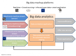
It is a typical use case of big data today, i.e.: using machine to machine stream to understand patterns (data correlation application) and then, from these patterns, build new predictive model for automatic decision making (see diagram below):
The results are two-folds:
- The predictive model of malaria spreading helps local authorities to focus their preventive campaigns (e.g. bed netting) on the right areas and population (most vulnerable)
- Using real-time analysis of mobile phone call and predictive model about population movements enables to send SMS messages to the travelers to warn them about the dangers and inform them about safe procedures they can follow to protect themselves from the disease. These warning campaigns could also rely in the future on other additional data coming from weather forecast and satellite images which could be useful to understand better mosquitos’ behavior and will be included into the predictive model.
The second example is about using our smartphone as an earthquake detector and alert tools for population (densely populated cities or remote outlets). All smartphones contain a device, called micro-electro-mechanical systems accelerometers, which measures movement in three dimensions and tell the phone’s screen to flip from horizontal to vertical when the phone tilts. Recent studies (Journal bulletin of the Seismological society of America, October 2013 issue) show that this device could detect earthquake from 4 and above degree of magnitude.
The idea is to use this technology to collect lots of data about small earthquakes (some that people are not affected by) in order to reinforce survey data and make better predictions. In remote outlets, where communication network infrastructure are not good (in poor countries or any country after a major and destructive earthquake), accelerometer data could be used to alert population from aftershock.
Some scientific teams in the world suggest that manufacturers could develop such devices for the sole purpose of collecting seismic data, and distribute them to emergency management teams in earthquake-prone cities. The accelerometer embedded into our smart phone are not sensitive enough to detect small or very small earthquake (< 4 degree of magnitude). Some research group is now testing new accelerometer model that they say is 100 times more sensitive than the one currently used in smartphones, which may be sensitive enough to accurately record small-scale earthquakes.
The late Steve Job said “the iPhone is not a phone”, but a multimedia device (with lots of services, one of which is … the telephone). Right now, enterprises, public services and communities should use the enormous potential of cell phone networks (ubiquitous network infrastructure everywhere, more and more bandwidth) and big data collected through them to develop new services that will reach people wherever they live, e.g. crowded cities or remote outlets.

 English | EN
